


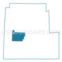
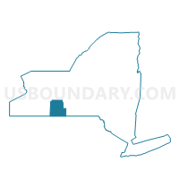
Voting District 070004, Steuben County, New York
About
Outline

Summary
| Unique Area Identifier | 636825 |
| Name | Voting District 070004 |
| County | Steuben County |
| State | New York |
| Area (square miles) | 53.43 |
| Land Area (square miles) | 53.42 |
| Water Area (square miles) | 0.01 |
| % of Land Area | 99.98 |
| % of Water Area | 0.02 |
| Latitude of the Internal Point | 42.23788710 |
| Longtitude of the Internal Point | -77.53541780 |
Maps

Graphs
Select a template below for downloading or customizing gragh for Voting District 070004, Steuben County, New York


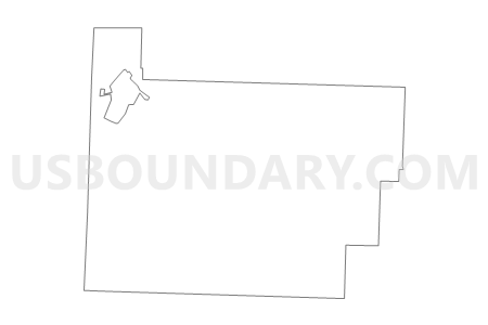
Neighbors
Neighoring Voting District (by Name) Neighboring Voting District on the Map
- Voting District 030001, Steuben County, NY
- Voting District 050001, Steuben County, NY
- Voting District 070001, Steuben County, NY
- Voting District 070002, Steuben County, NY
- Voting District 070003, Steuben County, NY
- Voting District 150001, Steuben County, NY
- Voting District 160001, Steuben County, NY
- Voting District 190002, Steuben County, NY
- Voting District 200001, Steuben County, NY
- Voting District 210001, Steuben County, NY
Top 10 Neighboring County Subdivision (by Population) Neighboring County Subdivision on the Map
- Bath town, Steuben County, NY (12,379)
- Hornellsville town, Steuben County, NY (4,151)
- Canisteo town, Steuben County, NY (3,391)
- Howard town, Steuben County, NY (1,467)
- Jasper town, Steuben County, NY (1,424)
- Cameron town, Steuben County, NY (945)
- Greenwood town, Steuben County, NY (801)
- Hartsville town, Steuben County, NY (609)
Top 10 Neighboring Place (by Population) Neighboring Place on the Map
Top 10 Neighboring Unified School District (by Population) Neighboring Unified School District on the Map
- Bath Central School District, NY (11,380)
- Addison Central School District, NY (7,115)
- Canisteo-Greenwood Central School District, NY (5,884)
- Jasper-Troupsburg Central School District, NY (3,415)
Top 10 Neighboring State Legislative District Lower Chamber (by Population) Neighboring State Legislative District Lower Chamber on the Map
Top 10 Neighboring State Legislative District Upper Chamber (by Population) Neighboring State Legislative District Upper Chamber on the Map
Top 10 Neighboring 111th Congressional District (by Population) Neighboring 111th Congressional District on the Map
Top 10 Neighboring Census Tract (by Population) Neighboring Census Tract on the Map
- Census Tract 9611, Steuben County, NY (4,616)
- Census Tract 9620, Steuben County, NY (4,437)
- Census Tract 9606, Steuben County, NY (4,152)
- Census Tract 9610, Steuben County, NY (3,731)
- Census Tract 9618, Steuben County, NY (3,421)
- Census Tract 9619, Steuben County, NY (3,391)
Top 10 Neighboring 5-Digit ZIP Code Tabulation Area (by Population) Neighboring 5-Digit ZIP Code Tabulation Area on the Map
- 14843, NY (13,043)
- 14810, NY (12,356)
- 14823, NY (3,754)
- 14806, NY (2,269)
- 14855, NY (956)
- 14839, NY (793)
- 14819, NY (733)